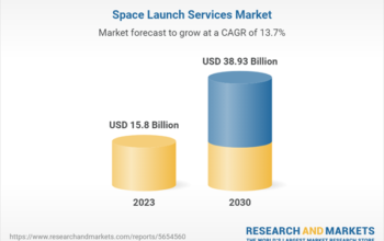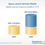

According to a new report published by UnivDatos Markets Insights, the Commercial Satellite Imaging Market was valued at USD 3.8 billion in 2020 and is expected to grow at a CAGR of 11% from 2022-2028.
The analysis has been segmented into Application (Geospatial Data Acquisition, Urban Planning, Disaster Management, Natural Resource Management, Surveillance, Defense & Intelligence, and Others); End-User (Government, Military & Defense, Forestry & Agriculture, Civil Engineering, Transportation, and Others); Region/Country.
The global commercial satellite imaging market is uplifting on account of the increasing usage of satellite imagery for commercial purposes like defense, agriculture, energy etc., and rising concerns about climatic changes, environmental degradation, as well as disaster monitoring.
Moreover, deforestation monitoring followed by the growing security concerns and geopolitical tensions between countries will positively stimulate the industry landscape. Further on, the rising budget of various space agencies is significantly contributing to the growth of this market. For instance, NASA's budget stood at USD 23.3 Bn in 2021 which rose to USD 24 Bn in 2022. The increasing investment in aerospace industry startups is also driving the growth of the commercial satellite imaging market.
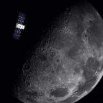
Moreover, commercial satellite imaging is primarily related to the acquisition of images of Earth by satellites, and the use of these images for a variety of commercial purposes is known as commercial satellite imaging.
Commercial Satellite Imaging Market will See CAGR of 11% (2022-2028) owing to Smart Cities and Connected Vehicles
NOIDA, India, Nov. 11, 2022 — According to a new report published by UnivDatos Markets Insights, the Commercial Satellite Imaging Market was valued at USD 3.8 billion in 2020 and is expected to grow at a CAGR of 11% from 2022-2028. The analysis has been segmented into Application (Geospatial Data Acquisition, Urban Planning, Disaster Management, Natural Resource Management, Surveillance, Defense & Intelligence, and Others); End-User (Government, Military & Defense, Forestry & Agriculture, Civil Engineering, Transportation, and Others); Region/Country.
The Commercial Satellite Imaging market report has been aggregated by collecting informative data on various dynamics such as market drivers, restraints, and opportunities. This innovative report makes use of several analyses to get a closer outlook on the Commercial Satellite Imaging market. The Commercial Satellite Imaging market report offers a detailed analysis of the latest industry developments and trending factors in the market that are influencing the market growth. Furthermore, this statistical market research repository examines and estimates the Commercial Satellite Imaging market at the global and regional levels.
Market Overview
The global commercial satellite imaging market is uplifting on account of the increasing usage of satellite imagery for commercial purposes like defense, agriculture, energy, and others and rising concerns about climatic changes, environmental degradation, and disaster monitoring. Moreover, deforestation monitoring followed by the growing security concerns and geopolitical tensions between countries will positively stimulate the industry landscape. Further on, the rising budget of various space agencies is significantly contributing to the growth of this market. For instance, NASA's budget stood at USD 23.3 Bn in 2021 which rose to USD 24 Bn in 2022. The increasing investment in aerospace industry startups is also driving the growth of the commercial satellite imaging market.
Moreover, commercial satellite imaging is primarily related to the acquisition of images of the Earth by satellites, and the use of these images for a variety of commercial purposes is known as commercial satellite imaging.
COVID-19 Impact
The recent covid-19 pandemic has disrupted the world and has brought a state of the frozen supply chain to the global economy. For most major space makers, the COVID-19 pandemic has disrupted mission operations and delayed new product shipments due to supply chain disruptions. The pandemic also affected the revenue sources allocated to research and development and the adoption of new technologies in the commercial satellite imagery sector.
The global commercial satellite imaging market report is studied thoroughly with several aspects that would help stakeholders in making their decisions more curated.
The global commercial satellite imaging market report is studied thoroughly with several aspects that would help stakeholders in making their decisions more curated.
- On the basis of application, the market is divided into geospatial data acquisition, urban planning, disaster management, natural resource management, surveillance, defense & intelligence, and others. The defense & intelligence segment accounted for a commendable share of the commercial satellite imaging market mainly owing to services provided by satellite imagery to the government and defense agencies for several types of applications such as image fusion, change detection, and land cover classification.
- Based on end-user, the market is segmented into government, military & defense, forestry & agriculture, civil engineering, transportation, and others. Among these categories, the military & defense segment is expected to showcase a prominent CAGR during the forecast period. Commercial satellite imaging also provides location-based services that help during floods, rescue events, natural calamities, and weather forecasting to develop future programs to simplify situational events.
Commercial Satellite Imaging Market Geographical Segmentation Includes:
- North America (US, Canada, Rest of North America)
- Europe (Germany, France, Spain, the UK, Rest of Europe)
- Asia-Pacific (China, Japan, India, South Korea, Rest of Asia-Pacific)
- Rest of the World
North America accounted for a prominent share of the global commercial satellite imaging and is expected to grow at a significant growth rate during the forecast period owing to the rapid adoption of commercial satellite imaging across several industries in the region. In addition, the rapidly growing military spending is further contributing to the growth of this market in the region.
The major players targeting the market include
- BlackSky Technology Inc.
- European Space Imaging GmbH
- Galileo Inc.
- Harris Corporation
- ImageSat International N.V.
- Maxar Technologies Inc.
- Planet Labs PBC
- SpaceKnow Inc.
- Telespazio Spa
- UrtheCast Corp
Competitive Landscape
The degree of competition among prominent global companies has been elaborated by analyzing several leading key players operating worldwide. The specialist team of research analysts sheds light on various traits such as global market competition, market share, most recent industry advancements, innovative product launches, partnerships, mergers, or acquisitions by leading companies in the Commercial Satellite Imaging Market. The major players have been analyzed by using research methodologies for getting insight views on global competition.
Key questions resolved through this analytical market research report include:
- What are the latest trends, new patterns, and technological advancements in the Commercial Satellite Imaging market?
- Which factors are influencing the Commercial Satellite Imaging market over the forecast period?
- What are the global challenges, threats, and risks in the Commercial Satellite Imaging market?
- Which factors are propelling and restraining the Commercial Satellite Imaging market?
- What are the demanding global regions of the Commercial Satellite Imaging market?
- What will be the global market size in the upcoming years?
- What are the crucial market acquisition strategies and policies applied by global companies?
Commercial Satellite Imaging Market Report Coverage
Report Attribute | Details |
Base year | 2020 |
Forecast period | 2022-2028 |
Growth momentum | Accelerate at a CAGR of 11% |
Market size 2020 | USD 3.8 billion |
Regional analysis | North America, Europe, APAC, Rest of World |
Major contributing region | North America to Dominate the Global Commercial Satellite Imaging Market |
Key countries covered | United States, Canada, Germany, United Kingdom, Spain, France, China, Japan, India, South Korea |
Companies profiled | BlackSky Technology Inc., European Space Imaging GmbH, Galileo Inc., Harris Corporation, ImageSat International N.V., Maxar Technologies Inc., Planet Labs PBC, SpaceKnow, Inc., Telespazio Spa, and UrtheCast Corp. |
Report Scope | Market Trends, Drivers, and Restraints; Revenue Estimation and Forecast; Segmentation Analysis; Impact of COVID-19; Demand and Supply Side Analysis; Competitive Landscape; Company Profiling |
Segments Covered | By Application; By End-User; By Region/Country |
For corrections or follow-up: editor@spaceinfohub
You may like these posts too:
- Virgin Galactic Selects Primary Suppliers for its Delta Class Spaceships
- Satellogic Signs LOI with Mexico’s Space Agency
- OPTAGE Builds Its Fifth Data Center in Osaka, Japan
- Momentus Launches Vigoride Orbital Service Vehicle
- L3Harris to Acquire Aerojet Rocketdyne
- iSun Inc. completes $16.4 million transaction of development project